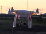
DJI Phantom 3 drone video review
Check out this video review of the DJI Phantom 3 Professional Quadcopter drone.
Drones are getting used more and more for a number of agricultural uses.
From inspecting fences, dams and troughs in hard to reach paddocks, to scaring birds from crops, to monitoring the health of your fields using infra-red cameras and normalised difference vegetation index (NDVI) technology.
You can also use unmanned aerial vehicles (UAVs) for mapping and surveying purposes.
Using software you can stitch your images together to create detailed aerial maps, topographic and terrain maps as well as 3D models from which you are able to take accurate volumetrics and measurements.
This allows you to easily and accurately measure parcels of land, so you’ll know exactly the size of the area you intend to sow.
Or the length of the new fence that needs to be erected or the amount of lime or feed or whatever you have left in the stockpile or haystack.
Without leaving the workshop, farmers can quickly check water levels at tanks and dams, monitor stock and make sure gates are shut.
The DJI Phantom 3 Professional Quadcopter and other UAVs [Unmanned Aerial Vehicles], are certain to be popular among time poor, money conscience, tech savvy farmers now and into the future.
Read more here.
Keep up to date in the industry by signing up to Farm Trader's free newsletter or liking us on Facebook
.jpg)
.jpeg)